Durch die Marsch


- 1:35 h
- 6.60 km
- 10 m
- 13 m
- 6 m
- 20 m
- 14 m
- Destination: Clüverhaus, Große Kirchenstraße 1
Originally used as pastureland, it is now mostly used for arable farming. The circular route leads from the old village of Achim into the Achim marshes, past the historic St. Laurentius church and the thatched gallery Dutch windmill, a meadow orchard and a distinctive hedgerow landscape.
Tip: Take a look back at the village of Achim. In 1892, the travel writer "August Freudenthal" described the "stately, beautiful landscape" and the view of "picturesque Achim" in the second book of his Heidefahrten.
Way description:
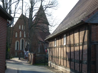
You start the hike at the historic St. Laurentius Church (1) in the "old village of Achim". The dark blue hiking trail signage begins in the parking lot.
Walk down the stairs in a southerly direction down "Kleine Kirchenstraße". At the end, turn right into Unterstraße and then keep left after a few meters. As the street name "Zur Achimer Marsch" suggests, the path leads from here into the marsh (2). The rainwater retention basin (3) is now on your left, then cross the bridge over the ditch (4) and you will see a memorial stone (5) and the orchard meadow (6). Take the right-hand path and follow it straight ahead. Tip: On the rest of the route, take note of the typical marshy landscapes interspersed with hedges (7). In the southern section of the circular route, keep left twice on the paved hiking trail (8 and 9).
(Shortcut: From here, you can walk straight back to "Unterstraße" and St. Laurentius Church via a short route and with a particularly beautiful view of the village of Achim.)
For the way back, we recommend turning right and following the path past the Hirtenhaus restaurant (10) via the "Marsch-Anna-Weg" to the road "An der Marsch". Turn left at Marsch and walk a short distance to a small footpath on the right. This leads into the street "Zum Wischkamp". Turn left and follow the road for a short distance until a small path on the right leads up the Geesthang. From here you come to the road "Am Westerfeld". Now turn left and you will pass the Achim windmill (11). Continue straight ahead into "Mühlenstraße" and then turn left into "Marschstraße". Via "Langenstraße" and "Unterstraße" you will return to the starting point of the hiking trail and to St. Laurentius Church.
Sightseeing/interesting facts:
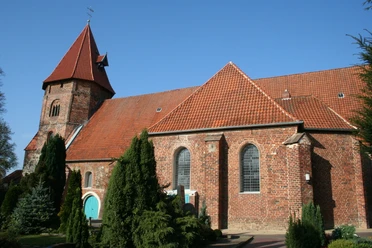
(1) St. Laurentius Church and the "old village of Achim":
The building, first mentioned in a document in 1257, is the oldest building in the town. The church served as a refuge in times of war and fire. Originally built as a Romanesque fieldstone building, the church was later extended to include two chapels. Worth seeing are the pulpit from 1631, the late Baroque altar from 1750 and a late Romanesque baptismal font. www.st-laurentius-achim.de, church tour: Achim Tourist Information, tel. (04202) 2949, www.achim.de.
The area with the historic St. Laurentius Church and the surrounding buildings is known as the Achim farming district or the "old village of Achim". Also worth seeing here is the Clüverhaus (Große Kirchenstraße 1), a typical Lower Saxon two-storey half-timbered farmhouse, which is now home to an integrative café.
(2) Achimer Marsch:
The Achimer Marsch is a farmland-pasture marsh. As part of the extensive Weser Marsh, it is an important resting place for wild geese, swans and waders during bird migration periods. In the winter months, large groups of whooper swans can often be observed here. The Achimer Marsch has been a protected landscape since 1974.
(3) Rainwater retention basin:
The rainwater retention basin provides plants and animals with a replacement habitat for filled-in oxbow lakes and pools in the Weser floodplain. The village's fire-fighting pond used to be located here.
(4) Memorial stone:
Under a small oak grove, you will discover the memorial stone for "melioration" (Latin for soil improvement - to increase agricultural productivity). It commemorates the construction of the concrete road between 1957 and 1960, which was a support program of the "Green Plan" to make the marsh more effective and easier to farm.
(5) Brücke über den Laufgraben:
The Achimer Marsch is part of the Aller-Weser glacial valley. In the late Middle Ages, the Aller used to run around here before flowing into the Weser at Bierden.
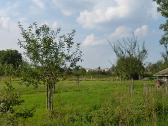
(6) Fruit meadow:
From apple to cherry and quince to walnut: there are now more than 100 fruit trees in the one-hectare meadow orchard created by NABU. Their rich structure encourages the colonization of birds and insects. The meadow shows the traditional form of fruit growing. Particular emphasis was placed on the cultivation of old, native high-stem varieties, which are hardly to be found today. In the past, orchards were used to provide food and as pasture. The grounds are open to the public. Tip: Take note of the interesting information boards!
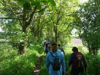
(7) Hedgerow landscape:
Today, the Achimer Marsch still has a well-developed hedgerow landscape. Hedges withstood the frequent flooding better than fences. They connect different biotopes with each other and provide cover, food, nesting sites and perches. Ideally, the hedge consists of a herbaceous border, shrubs (typically hawthorn) and overstory trees (usually oaks and ash trees).
(8) Historic brickworks and historic towpath
The Weser runs in front of us, concealed by hedges. In the middle of the 19th century, there were several brickworks on the meadows directly by the Weser, which were run by Achim farmers. The bricks produced were loaded onto ships on the Weser, transported to Bremen and sold there.
The towpath, also known as the towpath, ran along the banks of the Weser. This path had to be kept clear of hedges and fences, as it was used by people, the towmen, to pull the cargo ships upstream. Later, teams of horses and then steam-powered tugboats took over this hard work.
(9)Historical bathing place:
The Weser runs in front of us. This area of the river has been used as a bathing spot since 1880. In 1888, a wooden hut was erected and the first bathing establishment in Achim was built. By expanding and later relocating the bathing area, swimming festivals and sporting competitions could be held here until 1959.
(10) "Hirtenhaus Marsch Anna":
Initially just a shelter to protect the shepherd who tended the cattle in summer, a permanent shepherd's house was built in 1750 and again in 1831. There has been a pub in the house since 1834. At that time, many passing boatmen and linen haulers were guests there. After the opening of the bathing establishment, the pub became a much frequented place for excursions and is still a popular restaurant today. For a long time there was also a barge ferry here, which took you to the opposite side of the Weser, the English Hill. Tip: Take a look at the information board of the Achim local history association with historical photos.
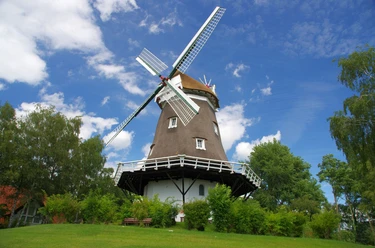
(11) Achim windmill:
The Holländer-Galerie windmill was built in 1761, is 29 m high, two-storey and has a thatched tower. In 1912, it was retrofitted with a wind rose and later an electric motor was installed. The mill was decommissioned in the 1960s. Since 1969, the "Verein zur Erhaltung der Achimer Windmühle e.V." has looked after the town's landmark. Guided tours of the mill: Achim Tourist Information Office, tel. (04202) 2949, www achim.de
The tour can also be found at Komoot.
Safety information:
Tip: Take a look back at the village of Achim. In 1892, the travel writer "August Freudenthal" described the "stately, beautiful landscape" and the view of "picturesque Achim" in the second book of his Heidefahrten.
Way description:
You start the hike at the historic St. Laurentius Church (1) in the "old village of Achim". The dark blue hiking trail signage begins in the parking lot.
Walk down the stairs in a southerly direction down "Kleine Kirchenstraße". At the end, turn right into Unterstraße and then keep left after a few meters. As the street name "Zur Achimer Marsch" suggests, the path leads from here into the marsh (2). The rainwater retention basin (3) is now on your left, then cross the bridge over the ditch (4) and you will see a memorial stone (5) and the orchard meadow (6). Take the right-hand path and follow it straight ahead. Tip: On the rest of the route, take note of the typical marshy landscapes interspersed with hedges (7). In the southern section of the circular route, keep left twice on the paved hiking trail (8 and 9).
(Shortcut: From here, you can walk straight back to "Unterstraße" and St. Laurentius Church via a short route and with a particularly beautiful view of the village of Achim.)
For the way back, we recommend turning right and following the path past the Hirtenhaus restaurant (10) via the "Marsch-Anna-Weg" to the road "An der Marsch". Turn left at Marsch and walk a short distance to a small footpath on the right. This leads into the street "Zum Wischkamp". Turn left and follow the road for a short distance until a small path on the right leads up the Geesthang. From here you come to the road "Am Westerfeld". Now turn left and you will pass the Achim windmill (11). Continue straight ahead into "Mühlenstraße" and then turn left into "Marschstraße". Via "Langenstraße" and "Unterstraße" you will return to the starting point of the hiking trail and to St. Laurentius Church.
Sightseeing/interesting facts:
(1) St. Laurentius Church and the "old village of Achim":
The building, first mentioned in a document in 1257, is the oldest building in the town. The church served as a refuge in times of war and fire. Originally built as a Romanesque fieldstone building, the church was later extended to include two chapels. Worth seeing are the pulpit from 1631, the late Baroque altar from 1750 and a late Romanesque baptismal font. www.st-laurentius-achim.de, church tour: Achim Tourist Information, tel. (04202) 2949, www.achim.de.
The area with the historic St. Laurentius Church and the surrounding buildings is known as the Achim farming district or the "old village of Achim". Also worth seeing here is the Clüverhaus (Große Kirchenstraße 1), a typical Lower Saxon two-storey half-timbered farmhouse, which is now home to an integrative café.
(2) Achimer Marsch:
The Achimer Marsch is a farmland-pasture marsh. As part of the extensive Weser Marsh, it is an important resting place for wild geese, swans and waders during bird migration periods. In the winter months, large groups of whooper swans can often be observed here. The Achimer Marsch has been a protected landscape since 1974.
(3) Rainwater retention basin:
The rainwater retention basin provides plants and animals with a replacement habitat for filled-in oxbow lakes and pools in the Weser floodplain. The village's fire-fighting pond used to be located here.
(4) Memorial stone:
Under a small oak grove, you will discover the memorial stone for "melioration" (Latin for soil improvement - to increase agricultural productivity). It commemorates the construction of the concrete road between 1957 and 1960, which was a support program of the "Green Plan" to make the marsh more effective and easier to farm.
(5) Brücke über den Laufgraben:
The Achimer Marsch is part of the Aller-Weser glacial valley. In the late Middle Ages, the Aller used to run around here before flowing into the Weser at Bierden.
(6) Fruit meadow:
From apple to cherry and quince to walnut: there are now more than 100 fruit trees in the one-hectare meadow orchard created by NABU. Their rich structure encourages the colonization of birds and insects. The meadow shows the traditional form of fruit growing. Particular emphasis was placed on the cultivation of old, native high-stem varieties, which are hardly to be found today. In the past, orchards were used to provide food and as pasture. The grounds are open to the public. Tip: Take note of the interesting information boards!
(7) Hedgerow landscape:
Today, the Achimer Marsch still has a well-developed hedgerow landscape. Hedges withstood the frequent flooding better than fences. They connect different biotopes with each other and provide cover, food, nesting sites and perches. Ideally, the hedge consists of a herbaceous border, shrubs (typically hawthorn) and overstory trees (usually oaks and ash trees).
(8) Historic brickworks and historic towpath
The Weser runs in front of us, concealed by hedges. In the middle of the 19th century, there were several brickworks on the meadows directly by the Weser, which were run by Achim farmers. The bricks produced were loaded onto ships on the Weser, transported to Bremen and sold there.
The towpath, also known as the towpath, ran along the banks of the Weser. This path had to be kept clear of hedges and fences, as it was used by people, the towmen, to pull the cargo ships upstream. Later, teams of horses and then steam-powered tugboats took over this hard work.
(9)Historical bathing place:
The Weser runs in front of us. This area of the river has been used as a bathing spot since 1880. In 1888, a wooden hut was erected and the first bathing establishment in Achim was built. By expanding and later relocating the bathing area, swimming festivals and sporting competitions could be held here until 1959.
(10) "Hirtenhaus Marsch Anna":
Initially just a shelter to protect the shepherd who tended the cattle in summer, a permanent shepherd's house was built in 1750 and again in 1831. There has been a pub in the house since 1834. At that time, many passing boatmen and linen haulers were guests there. After the opening of the bathing establishment, the pub became a much frequented place for excursions and is still a popular restaurant today. For a long time there was also a barge ferry here, which took you to the opposite side of the Weser, the English Hill. Tip: Take a look at the information board of the Achim local history association with historical photos.
(11) Achim windmill:
The Holländer-Galerie windmill was built in 1761, is 29 m high, two-storey and has a thatched tower. In 1912, it was retrofitted with a wind rose and later an electric motor was installed. The mill was decommissioned in the 1960s. Since 1969, the "Verein zur Erhaltung der Achimer Windmühle e.V." has looked after the town's landmark. Guided tours of the mill: Achim Tourist Information Office, tel. (04202) 2949, www achim.de
The tour can also be found at Komoot.
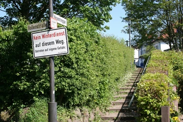
Safety information:
- Throughout the entire tour, please note that the paths are used at your own risk
- No guarantee is given for the usability of the paths
- In the towns/places, increased attention is generally required
- On the tour, you must expect to encounter danger points, such as bollards, barriers and unsecured crossings
Waypoints
Good to know
Best to visit
suitable
Depends on weather
Directions
Author
Mittelweser-Touristik GmbH
Lange Straße 18
31582 Nienburg/Weser
Organization
Mittelweser-Touristik GmbH
License (master data)
Mittelweser-Touristik GmbH

Nearby
