Vör de Döör (Vor der Tür)


- 1:48 h
- 7.40 km
- 19 m
- 25 m
- 6 m
- 26 m
- 20 m
- Destination: Am Blocksberg (parking lot)
Way description:
From the parking lot (1-3), walk along the street "Am Blocksberg" until you reach "Allerstraße". There, turn right into the marsh (4). If you now walk into the marsh, you will come to the lock canal (5). Cross the canal and follow the road. Turn left at the next but one junction (6). Turn right at the crossroads and take the next left over a dirt road to reach the country road. If you now turn left towards Etelsen, you will cross the lock canal for the second time. From the bridge, you have a view of the canal lock (7) to the east. Continue straight ahead on the country road and cross the Alte Aller (8) shortly before the village of Etelsen. At the entrance to Etelsen, turn left and follow the road. Etelsen Castle with its castle garden and mausoleum is on the right (9). For a detour into the Etelsen castle garden, which is well worth seeing, go through a small gate from the south.
Continue in the direction of the sports field. Here you can either take a shortcut and follow the asphalt road straight ahead, or you can continue along the beautiful natural path through the forest. Keep slightly to the right before the sports field and then walk behind the field until the path makes a slight bend to the right up the slope. Then take the next left turn through the forest and continue straight ahead. At the road "Am Sonnenhang" (10), turn left until you reach "Allerstraße". Finally, continue straight on via the road "Am Blocksberg" back to the starting point.
Sightseeing/interesting facts:
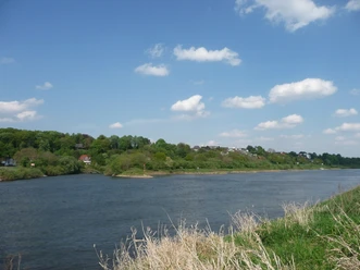
(1) Badener Berge:
The Achim district of Baden is located on one of the last Geest ridges in northern Germany and has the highest elevation in the area, the Schraderberg (approx. 48m above sea level). The area is part of a once mighty chain of inland dunes that formed around 10,000 years ago at the end of the last ice age and stretched from Bremen to Nienburg. The Weser, Alte Aller and the lock canal meet at the foot of the Badener Berge. Terracing of the Badener Weser slope in the 19th century opened up a wide view over the Weser marshes. For the people of Bremen, the Badener Hochufer became a worthwhile excursion destination early on: on Sundays and public holidays, many excursionists took advantage of the steamboat trips from Bremen to the Badener mountains.
The Weser slope offers a unique habitat for numerous animal and plant species due to its shade-free southern exposure. Wild bees and wasp species in particular, many of which are on the Red List, have a chance of survival here. If you take some time to rest on the slope in early summer, you can often hear the nightingale singing from the herbaceous hedges along the banks of the Weser - and not just in the evening! Tip: Please also take a look at the NABU information boards on the flora and fauna of the Weser slope.
(2) Karlheinz-Gerhold-Platz:
The square, known for the traditional family festival "Badener Pfingstwiese" during the Whitsun holidays, was named in 2017 after the local historian, publicist and local politician Karlheinz Gerhold, who died in spring 2016.
(3) Memorial stone 1000 years of Baden:
The four-tonne boulder, a migmatite, was dredged up in 2010 during the widening of the lock canal and brought to the Weser slope by low-loader a year later. The memorial stone was erected to mark the 1000th anniversary of the Achim district of Baden. The coat of arms of the municipality of Baden, which was valid until 1972, is depicted in the middle of the stone. Symbolically divided by the Weser bend (Weserbogen), the coat of arms shows the Bremen key lying in the upper part, which, according to the official description of the coat of arms from 1961, is intended to express Baden's close connection with the city and state of Bremen. The horse's head growing from the lower edge of the shield refers to agriculture and horse breeding in the Baden region.
(4) Marsch:
This marsh has also changed considerably over time due to increased arable use. Numerous hedges and trees fell victim to this transformation.
(5) Schleusenkanal:
The lock canal has a length of 8.51 km, begins at Verden and flows back into the Weser here in Baden at the so-called Weserbogen. The aim of straightening the river was to shorten the journey times of the still important cargo shipping industry. This project, which had been planned for decades and had already been partially realized, was started in Baden in February 1937. From the bend in the Weser, the first dredging work began along a length of around 200 meters in the direction of Langwedel. The farm road to the pastures east of the Weser bend was interrupted by the canal. The canal bridge was built to provide access for milkers etc. and was used accordingly. The bridge stood alone in the pastures during the last war; the associated canal was not built until the early 1950s.
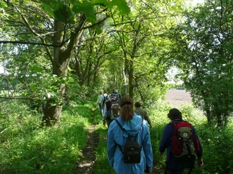
(6) Hedgerow landscape:
Hedgerows link different biotopes with each other and provide cover, food, nesting sites and perches at the same time. Ideally, the hedge consists of a herbaceous border, shrubs (typically hawthorn) and overstory trees (usually oaks and ash trees).
(7) Canal lock:
The lock was built between 1955 and 1958 under the direction of the Verden Water and Shipping Authority and was completed in June 1958 as the "Langwedel impoundment". The lock has a usable length of 215 meters, a width of 12.36 meters and a maximum lifting height of 5.50 meters. With the construction of the Intschede barrage and the start of lock operation, tugboat navigation and rafting came to an end. Since 2010, lock operation has been controlled remotely by the Minden Waterways and Shipping Authority. Since then, there is no longer a local lock keeper. Tip: If you take a short detour to the right, you can stop off directly at the lock. Signs explain how to lock ships and boats.
(8) Old Aller:
Side arms of the Aller (so-called old arms) that have not yet completely silted up are known as the "Old Aller". It stretches from Daverden to Etelsen, connected by canals. Here it flows into the Weser via a ditch at Badener Berg. Pochards, coots and mute swans breed in the reed belt of the "Alte Aller". In winter, whooper swans are often seen on the grassland as guests from northern Europe, who like to stay here in groups.
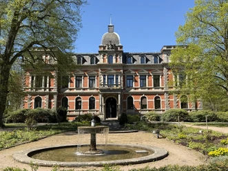
(9) Etelsen Castle with castle park and mausoleum:
A castle like in "One Thousand and One Nights": built in 1886 in neo-Renaissance style, Etelsen Castle has had a varied history through various owners and uses.
Since the 1980s, now owned by the district of Verden, numerous cultural events such as concerts and exhibitions have been held here and, since the 2000s, civil weddings have also taken place.
The approximately ten-hectare castle park with its beautiful old trees was created by the ducal promenade inspector Friedrich Kreiß and is open to the public. The park is home to the mausoleum, which was built in 1873 in neo-Gothic style by the famous architect Conrad Wilhelm Hase. It only served as a tomb for a few decades. After restoration in the 1980s, it is now used as an exhibition space. www.schloss-etelsen.de
(10) Sonnenhang:
The Sonnenhang used to be called "Drivden", or drift path. Heather and birch trees grew on the slope and sheep grazed there. Before the war, the people of Baden used to say "dor ünnen bood man nich", but the area later became sought-after building land.
You can also find the tour at Komoot.
Safety information:
From the parking lot (1-3), walk along the street "Am Blocksberg" until you reach "Allerstraße". There, turn right into the marsh (4). If you now walk into the marsh, you will come to the lock canal (5). Cross the canal and follow the road. Turn left at the next but one junction (6). Turn right at the crossroads and take the next left over a dirt road to reach the country road. If you now turn left towards Etelsen, you will cross the lock canal for the second time. From the bridge, you have a view of the canal lock (7) to the east. Continue straight ahead on the country road and cross the Alte Aller (8) shortly before the village of Etelsen. At the entrance to Etelsen, turn left and follow the road. Etelsen Castle with its castle garden and mausoleum is on the right (9). For a detour into the Etelsen castle garden, which is well worth seeing, go through a small gate from the south.
Continue in the direction of the sports field. Here you can either take a shortcut and follow the asphalt road straight ahead, or you can continue along the beautiful natural path through the forest. Keep slightly to the right before the sports field and then walk behind the field until the path makes a slight bend to the right up the slope. Then take the next left turn through the forest and continue straight ahead. At the road "Am Sonnenhang" (10), turn left until you reach "Allerstraße". Finally, continue straight on via the road "Am Blocksberg" back to the starting point.
Sightseeing/interesting facts:
(1) Badener Berge:
The Achim district of Baden is located on one of the last Geest ridges in northern Germany and has the highest elevation in the area, the Schraderberg (approx. 48m above sea level). The area is part of a once mighty chain of inland dunes that formed around 10,000 years ago at the end of the last ice age and stretched from Bremen to Nienburg. The Weser, Alte Aller and the lock canal meet at the foot of the Badener Berge. Terracing of the Badener Weser slope in the 19th century opened up a wide view over the Weser marshes. For the people of Bremen, the Badener Hochufer became a worthwhile excursion destination early on: on Sundays and public holidays, many excursionists took advantage of the steamboat trips from Bremen to the Badener mountains.
The Weser slope offers a unique habitat for numerous animal and plant species due to its shade-free southern exposure. Wild bees and wasp species in particular, many of which are on the Red List, have a chance of survival here. If you take some time to rest on the slope in early summer, you can often hear the nightingale singing from the herbaceous hedges along the banks of the Weser - and not just in the evening! Tip: Please also take a look at the NABU information boards on the flora and fauna of the Weser slope.
(2) Karlheinz-Gerhold-Platz:
The square, known for the traditional family festival "Badener Pfingstwiese" during the Whitsun holidays, was named in 2017 after the local historian, publicist and local politician Karlheinz Gerhold, who died in spring 2016.
(3) Memorial stone 1000 years of Baden:
The four-tonne boulder, a migmatite, was dredged up in 2010 during the widening of the lock canal and brought to the Weser slope by low-loader a year later. The memorial stone was erected to mark the 1000th anniversary of the Achim district of Baden. The coat of arms of the municipality of Baden, which was valid until 1972, is depicted in the middle of the stone. Symbolically divided by the Weser bend (Weserbogen), the coat of arms shows the Bremen key lying in the upper part, which, according to the official description of the coat of arms from 1961, is intended to express Baden's close connection with the city and state of Bremen. The horse's head growing from the lower edge of the shield refers to agriculture and horse breeding in the Baden region.
(4) Marsch:
This marsh has also changed considerably over time due to increased arable use. Numerous hedges and trees fell victim to this transformation.
(5) Schleusenkanal:
The lock canal has a length of 8.51 km, begins at Verden and flows back into the Weser here in Baden at the so-called Weserbogen. The aim of straightening the river was to shorten the journey times of the still important cargo shipping industry. This project, which had been planned for decades and had already been partially realized, was started in Baden in February 1937. From the bend in the Weser, the first dredging work began along a length of around 200 meters in the direction of Langwedel. The farm road to the pastures east of the Weser bend was interrupted by the canal. The canal bridge was built to provide access for milkers etc. and was used accordingly. The bridge stood alone in the pastures during the last war; the associated canal was not built until the early 1950s.
(6) Hedgerow landscape:
Hedgerows link different biotopes with each other and provide cover, food, nesting sites and perches at the same time. Ideally, the hedge consists of a herbaceous border, shrubs (typically hawthorn) and overstory trees (usually oaks and ash trees).
(7) Canal lock:
The lock was built between 1955 and 1958 under the direction of the Verden Water and Shipping Authority and was completed in June 1958 as the "Langwedel impoundment". The lock has a usable length of 215 meters, a width of 12.36 meters and a maximum lifting height of 5.50 meters. With the construction of the Intschede barrage and the start of lock operation, tugboat navigation and rafting came to an end. Since 2010, lock operation has been controlled remotely by the Minden Waterways and Shipping Authority. Since then, there is no longer a local lock keeper. Tip: If you take a short detour to the right, you can stop off directly at the lock. Signs explain how to lock ships and boats.
(8) Old Aller:
Side arms of the Aller (so-called old arms) that have not yet completely silted up are known as the "Old Aller". It stretches from Daverden to Etelsen, connected by canals. Here it flows into the Weser via a ditch at Badener Berg. Pochards, coots and mute swans breed in the reed belt of the "Alte Aller". In winter, whooper swans are often seen on the grassland as guests from northern Europe, who like to stay here in groups.
(9) Etelsen Castle with castle park and mausoleum:
A castle like in "One Thousand and One Nights": built in 1886 in neo-Renaissance style, Etelsen Castle has had a varied history through various owners and uses.
Since the 1980s, now owned by the district of Verden, numerous cultural events such as concerts and exhibitions have been held here and, since the 2000s, civil weddings have also taken place.
The approximately ten-hectare castle park with its beautiful old trees was created by the ducal promenade inspector Friedrich Kreiß and is open to the public. The park is home to the mausoleum, which was built in 1873 in neo-Gothic style by the famous architect Conrad Wilhelm Hase. It only served as a tomb for a few decades. After restoration in the 1980s, it is now used as an exhibition space. www.schloss-etelsen.de
(10) Sonnenhang:
The Sonnenhang used to be called "Drivden", or drift path. Heather and birch trees grew on the slope and sheep grazed there. Before the war, the people of Baden used to say "dor ünnen bood man nich", but the area later became sought-after building land.
You can also find the tour at Komoot.
Safety information:
- Throughout the entire tour, please note that the paths are used at your own risk
- No guarantee is given for the usability of the paths
- In the cities/towns, increased attention is generally required
- On the tour, you must expect to encounter danger spots, such as bollards, barriers and unsecured crossings
Waypoints
Destination
Good to know
Best to visit
suitable
Depends on weather
Author
Mittelweser-Touristik GmbH
Lange Straße 18
31582 Nienburg/Weser
Organization
Mittelweser-Touristik GmbH
License (master data)
Mittelweser-Touristik GmbH

Nearby


