Krähen-Tour


- 2:21 h
- 9.50 km
- 40 m
- 44 m
- 30 m
- 66 m
- 36 m
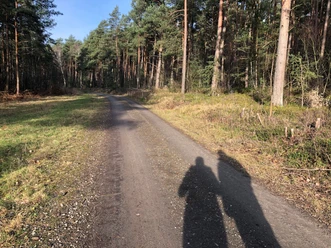
The approx. 10 km long hiking trail runs mostly on firm forest paths but also on sandy paths or narrow boggy paths, which can sometimes be slippery. There are hardly any major ascents and descents.
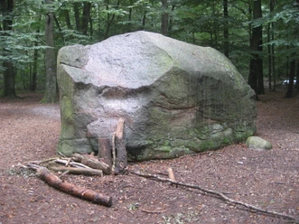
If you are traveling by car, it is best to start the hike at "Giebichenstein", where there are plenty of parking spaces. Here you will also see one of the highlights of your hike The Giebichenstein is an approx. 7.50 m long, 4.50 m wide, 2.75 m high and 207 t heavy boulder from the Saale Ice Age and is probably the largest glacial erratic boulder in Lower Saxony. The stone is the subject of a number of legends and tales. A few steps further east you will find the remains of a large stone grave from the early Stone Age.
If you are traveling by car, walk approx. 800 m in the direction of Kreisstraße 3. If you are arriving by bus, take bus number 40 and get off at the Stöckse - "Freilichtbühne" bus stop.
The description follows the black arrow on the signs.
At the boulder at the entrance to Stöckse, both those arriving by car and those arriving by bus cross the Kreisstraße 3 and walk along the "Alter Wölper Weg", which leads you along a long, straight forest path directly into the terminal moraine landscape of the Krähe. On the right-hand side of the path, you walk past meadows and then past the "Krähenmoor" nature reserve. On the left-hand side, the trail leads you through the Nienburg state forest with various coniferous and deciduous trees. The fauna can also be observed here.
After approx. 2.5 km you have to decide:
If you turn right, the path is no longer marked. However, you can then walk around the Krähenmoor on the northern side:
Here, the hiking trail leads you out of the forest towards the "Krähenmoor" nature reserve. After approx. 500 m, the path curves to the left along the Krähenmoor. After a further 500 m, turn right onto a path approx. 150 m long, which separates the Krähenmoor from the Bunkenmoor; here you have a view of the Krähenmoor to the right and the Bunkenmoor to the left. You then walk along a very idyllic path, where you can see a mixed forest that has grown over the years on the right and the Bunkenmoor on the left. The moor is predominantly characterized by birch-pine moorland forest and pipe grass stands.
The Schiffgraben flows through the Bunkenmoor. In the area of the Schiffgraben, there are artificial ponds in places. There is a small open shelter on the other side of the hiking trail at one of these bodies of water. You should not leave the marked paths on your hike, as both Krähenmoor and Bunkenmoor are not accessible to the public; they are located in a nature reserve. Hikers are informed of this in many places. You now continue in the direction of district road 46, after approx. 500 you turn left and unfortunately walk along the district road for a while. At Forsthaus Krähe you cross the district road and walk along a small path that leads past the forester's lodge towards the "Zur Krähe" hotel and inn. Here you cross the district road 3.
Or you can continue to follow the markings and walk south along the Krähenmoor:
Then you come out of the forest on the district road 3 and have to turn right
in the direction of the hotel-inn "Zur Krähe". Here you cross the district road 3.
Now the path leads about 800 m on a paved road to the turn-off to Giebichenstein. From here you have a wonderful view of a secluded riding stables and meadows with grazing horses. When you reach the turn-off to Giebichenstein, you walk for another 40 minutes on a wide, sandy but idyllic path that leads through a beautiful forest dominated by beech trees to Giebichenstein. The undergrowth invites you to pick wild berries and cranberries and, in the fall, mushrooms. In many places, the forest path is lined with impressive ferns.
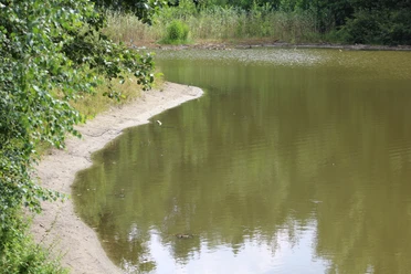
The fact that the path is also popular with horse riders can be seen from the natural jumps along the edge of the forest. The tranquillity here also gives you the opportunity to observe native game species. Once you have arrived at Giebichenstein after a 2-2.5 hour hike, you can take a small connecting path to reach the small but idyllic Stöckser See lake, which is somewhat hidden away. The lake invites you to linger, enjoy a picnic or take a dip in the cool water before heading back home.
If you have arrived by bus, you can reach the "Freilichtbühne" bus stop on Kreisstraße 3 from Giebichenstein in approx. 10 minutes in the direction of Stöckse town center.
The tour can also be found at Komoot.
Safety instructions:
If you are traveling by car, it is best to start the hike at "Giebichenstein", where there are plenty of parking spaces. Here you will also see one of the highlights of your hike The Giebichenstein is an approx. 7.50 m long, 4.50 m wide, 2.75 m high and 207 t heavy boulder from the Saale Ice Age and is probably the largest glacial erratic boulder in Lower Saxony. The stone is the subject of a number of legends and tales. A few steps further east you will find the remains of a large stone grave from the early Stone Age.
If you are traveling by car, walk approx. 800 m in the direction of Kreisstraße 3. If you are arriving by bus, take bus number 40 and get off at the Stöckse - "Freilichtbühne" bus stop.
The description follows the black arrow on the signs.
At the boulder at the entrance to Stöckse, both those arriving by car and those arriving by bus cross the Kreisstraße 3 and walk along the "Alter Wölper Weg", which leads you along a long, straight forest path directly into the terminal moraine landscape of the Krähe. On the right-hand side of the path, you walk past meadows and then past the "Krähenmoor" nature reserve. On the left-hand side, the trail leads you through the Nienburg state forest with various coniferous and deciduous trees. The fauna can also be observed here.
After approx. 2.5 km you have to decide:
If you turn right, the path is no longer marked. However, you can then walk around the Krähenmoor on the northern side:
Here, the hiking trail leads you out of the forest towards the "Krähenmoor" nature reserve. After approx. 500 m, the path curves to the left along the Krähenmoor. After a further 500 m, turn right onto a path approx. 150 m long, which separates the Krähenmoor from the Bunkenmoor; here you have a view of the Krähenmoor to the right and the Bunkenmoor to the left. You then walk along a very idyllic path, where you can see a mixed forest that has grown over the years on the right and the Bunkenmoor on the left. The moor is predominantly characterized by birch-pine moorland forest and pipe grass stands.
The Schiffgraben flows through the Bunkenmoor. In the area of the Schiffgraben, there are artificial ponds in places. There is a small open shelter on the other side of the hiking trail at one of these bodies of water. You should not leave the marked paths on your hike, as both Krähenmoor and Bunkenmoor are not accessible to the public; they are located in a nature reserve. Hikers are informed of this in many places. You now continue in the direction of district road 46, after approx. 500 you turn left and unfortunately walk along the district road for a while. At Forsthaus Krähe you cross the district road and walk along a small path that leads past the forester's lodge towards the "Zur Krähe" hotel and inn. Here you cross the district road 3.
Or you can continue to follow the markings and walk south along the Krähenmoor:
Then you come out of the forest on the district road 3 and have to turn right
in the direction of the hotel-inn "Zur Krähe". Here you cross the district road 3.
Now the path leads about 800 m on a paved road to the turn-off to Giebichenstein. From here you have a wonderful view of a secluded riding stables and meadows with grazing horses. When you reach the turn-off to Giebichenstein, you walk for another 40 minutes on a wide, sandy but idyllic path that leads through a beautiful forest dominated by beech trees to Giebichenstein. The undergrowth invites you to pick wild berries and cranberries and, in the fall, mushrooms. In many places, the forest path is lined with impressive ferns.
The fact that the path is also popular with horse riders can be seen from the natural jumps along the edge of the forest. The tranquillity here also gives you the opportunity to observe native game species. Once you have arrived at Giebichenstein after a 2-2.5 hour hike, you can take a small connecting path to reach the small but idyllic Stöckser See lake, which is somewhat hidden away. The lake invites you to linger, enjoy a picnic or take a dip in the cool water before heading back home.
If you have arrived by bus, you can reach the "Freilichtbühne" bus stop on Kreisstraße 3 from Giebichenstein in approx. 10 minutes in the direction of Stöckse town center.
The tour can also be found at Komoot.
Safety instructions:
- Throughout the entire tour, please note that the paths are used at your own risk
- No guarantee is given for the usability of the paths
- In the towns/villages, increased attention is generally required
- On the tour, you must expect to encounter danger spots, such as bollards, barriers to traffic
- .e.g. bollards, barriers and unsecured crossings

Waypoints
Good to know
Best to visit
suitable
Depends on weather
Author
Mittelweser-Touristik GmbH
Lange Straße 18
31582 Nienburg/Weser
Organization
Mittelweser-Touristik GmbH
License (master data)
Mittelweser-Touristik GmbH

Nearby
