Durch die Melchiorshauser Fuhren


- 0:31 h
- 2.10 km
- 9 m
- 8 m
- 15 m
- 27 m
- 12 m
- Start: Ristedter Straße on the B6
- Destination: Ristedter Straße on the B6
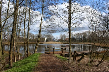
We take the wide forest path, which we immediately leave to the right, entering a wide grassy path. We walk through pine forest almost to the edge of the forest and keep left. Bizarrely shaped oak trees stand at the edge of the path, with new planting to the left and right. The path bends to the right and then immediately to the left again. We emerge from the forest and walk past beehives. We see wind turbines ahead of us, the former Ristedter Moor in front of the Geest slope, the Hoher Berg near Gessel with its observation tower, which is worth another walk because of its possible distant view of Bremen and the Weserurstrom valley, and when we reach the end of the path, the Barrien fire station tower.
We keep left, but at the first opportunity we turn left onto a small path, which leads us back to a wide and hilly grass path. We follow this to the right and turn right again at the next crossing. We return to our old path at the edge of the forest. Passing a house, we reach the B6, which we cross carefully. Opposite, we again pass a house and enter the forest, immediately take the small path under tall beech trees to the left, then immediately turn sharp right again.
The path leads us in a small curve back into the forest. At the crossroads, keep right and then immediately left again. At the end of this path we come to some houses. We take the wide path to the left, walk past the Schützenhalle to the Waldkater crossroads and cross the B6 safely at the traffic lights. Now we follow Ristedter Straße for a short distance and arrive at the starting point. Even if it all sounds a bit complicated, don't worry, the wood is very small and you can't get lost.
On this short walk, which requires sturdy footwear due to possible muddy patches, we see the "Fuhren", a coniferous forest created around 200 years ago, consisting mostly of pine trees. This forest was created to protect the highway, now the B6, from drifting sand, which formed the small hills in the forest. However, there are also birch trees on this barren and in some areas rather damp ground, oaks as edge planting and a small area of beech trees. The municipality of Weyhe is the least wooded in the district of Diepholz, so it is worth taking a walk through this remnant of inland dunes on the edge of the Weser glacial valley.
In April 1945, when the British troops were retreating towards Bremen from the south, this forest came under heavy fire. Some soldiers lost their lives and were initially buried on the spot, but then transferred to an English military cemetery. On March 3, 1943, an English bomber crashed near the Schützenhalle after being fired on from the anti-aircraft position near Hörden (Weyhe). All the occupants were killed. There is still metal in some of the trees in this grove, so the wood cannot be processed in sawmills.
The pine forest was completely destroyed in the "storm of the century" on 13.11.1972 and then replanted. The forest paths consist of the tree roots piled up at the time, which have since collapsed. The oaks at the edge of the forest survived the hurricane and remained standing. The forest covers a total of 33 hectares and is managed by the "Forstinteressentenschaft Leeste/Melchiorshausen".
You can also find the tour at Komoot.
Safety information:
- Throughout the entire tour, please note that the paths are used at your own risk
- No guarantee is given for the usability of the paths
- In the cities/towns, increased attention is generally required
- On the tour, you must expect to encounter danger spots, such as bollards, barriers and unsecured crossings
Good to know
Best to visit
suitable
Depends on weather
Author
Mittelweser-Touristik GmbH
Lange Straße 18
31582 Nienburg/Weser
Organization
Mittelweser-Touristik GmbH
License (master data)
Mittelweser-Touristik GmbH

Nearby
Download GPX file